Friday, February 28, 2014

Choropleth Mapping Module 7

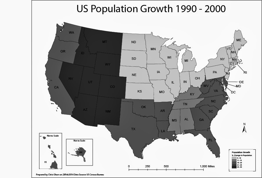
In this lab, I produced two choropleth maps showing population change in the United States of America. I used census data to illustrate the percent population change of each state for the period of April 1, 1990 to April 1, 2000. I used both ArcGIS and Adobe Illustrator to complete this assignment. 

A choropleth map is a thematic map in which enumeration units are shaded with an intensity proportional to the data values associated with those units.

The first map displayed population change percentage at the State Level. I used the Natural break method for the first map to split of the data. For this map I selected a light to dark khaki color ramp to show the change.

The second map will display population change at the level of U.S. Census Divisions.
On the second map I manually created the breaks into even divisions.


Friday, February 21, 2014

Data Classification Module 6


In this lab I explored the different ways that data can be displayed within ArcGIS. I displayed Equal Interval, Quantile, Standard Deviation, and Natural Break. This map displays the natural break. I choose this because it most accurately depicts the population of Escambia county. 

Thursday, February 20, 2014

Projections Part 2/Data Search Module 6


Week 6! This was a rough week, not everything went as planned in this lab. There were a few steps that I could not get due to user error or computer error. I tried all the trouble shooting that we had in the discussions post as well as with an instructor through email. Anyways this week I set out to find the information that I needed for the lab rather than the instructor spoon feed it to me. I visited LABINS and FGDL to gather data sets that were needed for the lab. After acquiring the data it had to be reprojected so that all the sets matched and projected on top of each other. This is where I ran into issues, no matter what I tried nothing seemed to work. So I moved on and used ArcGIS's on the fly projections to finish the lab and create the map above.

Friday, February 14, 2014

Spatial Statistics Module 5


In this lab I explored a couple of the statically analysis Tools that are avalible within ArcGIS. I used the histogram tool and the QQ tool to determine if the data followed a normal distribution. 

Thanks to mobile computing I was able to complete this post entirely from my phone. 

Thursday, February 13, 2014

Projections Part I Module 5


In this lab we loaded three different coordinate systems into ArcGIS to compare the differences between them. As you can see in the legend the square miles of each county is slightly different in each of the systems. This lab is a good example why it is important to watch which system that you are using.

Friday, February 7, 2014

Typography Module 4


This map was created in Adobe Illustrator. The purpose of this lab was to employ proper typography within the map. I added the labels to the map and ensured that the font, font size, and placement all worked together. I required to put three personal touches on the map. Can you tell what they are?

Thursday, February 6, 2014

ArcGIS Online & Map Packages Module 4


I created an ArcGIS online account, which will allow me to access and share map packages and do analysis via a web browser. 

Map packages are a way to share maps with other users, by supplying all the inputs of a project in a single source - the package.  Map packages contain map inputs, such as layers, data, and other documents.  By 'packaging' these items, the entire project is easily distributed and shared.  Similar to map packages, tile packages were discussed.  Tile packages contain both vector and raster graphics.  Tile packages break the map project into equal spaced tiles, the pieces of which makeup the total project.  Tiles are well suited for raster inputs.
Below are two screen shots of map packages that I created.